
Majik Forest
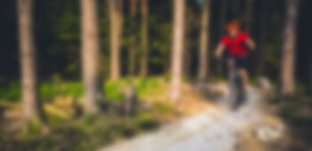
Majik Forest mountain bike trail is situated in the heart of the Durbanville suburbs, this trail is perfect for chasing the sunset after a long, hard day. Read more
place Bellville/Durbanville,
place Bellville/Durbanville,
Share your videos of Majik Forest
Majik Forest mountain bike trail is situated in the heart of the Durbanville suburbs, this trail is perfect for chasing the sunset after a long, hard day.
t is just a minute or two away from the Tyger Valley Shopping Centre, and has a nice combination of tough climbs to make those leg muscles burn, and single track… with everything in between;- fast smooth paths, rocky sections, bridges, drop-offs and some of the twisty-turny forest trails can be very exciting! The ride along the dam is entrancing, leading to a lovely piece of trail through the lower forest alongside the stream.
A typical loop of the trail can take from 50 minutes for the super fit, to 1 hour 40 minutes for the not-so-fit. Distances vary depending on the route you take, and range from 2km to 15km. All the trails are well marked with yellow arrows, you cannot really get lost, as all tracks are inter-leading. There is a black section at the top of Majik, with ascents that offer serious heart rate numbers and rocky drop-offs to test your bike control.
There is no entrance fee to ride here, but the trails are maintained by Tygerberg Mtb Club, so contributions are welcome (EFT details elsewhere on this website), or better still, join the Club!
There are two places to park, the first is Van Riebeeckshof Mall, where you can find a Spar, Bakuba Cafe for food, and WeBike for bike repairs and sales.
| Nearest Town: | Bellville/Durbanville |
| Website: | www.tygerbergmtb.co.za |
Want to view the location of this trail?
Login or Sign-up by clicking the button below.
Please note: Distance is calculated as air distance or "as the crow flies" the most direct route between two points, so the distance by road maybe slightly longer.
Disclaimer: All trails and location details have been submitted to this website by independent contributors and resources. We hold no personal responsibility for the accuracy or legality of any trail description or location published herein. All listings are for information only.
© More Dirt Ltd 2024. Company Number: 8034657. All content remains copyright of More Dirt Ltd unless stated otherwise...
